Cartes de visite juridique et finance
Cartes de visite marketing et com
Cartes de visite sport et fitness
Cartes de visite beauté et soins
Cartes de visite BTP et artisanat
Cartes de visite restauration
Cartes de visite photographie
Cartes de visite santé et bien-être
À propos
Have you ever looked back on photos from a trip, or retraced your route on a map and been underwhelmed? The hill you climbed seems so small, or the valley you drove down seems so flat. I love looking at maps, and though they’re great for navigation, they’re very bad at capturing the feeling of a location. They flatten important features of the terrain, like hills, ridges and valleys, that we instinctively recognise and remember when we’re there. In an effort to capture the magic of travel through amazing landscapes, I’ve refined a technique to represent the terrain in an ultra-realistic print, which exaggerates these important features, and using real satellite imagery. The result is a breathtaking interpretation of the terrain, which is much closer to the experience of seeing it than any photo or traditional map.
This beautiful effect is achieved by using digital elevation model data from the Copernicus satellite, combined with satellite imagery, which is then processed using 3D software, rendered and then printed on high quality matte paper (200 gsm) at very high resolution (300 dpi).
Tout voir
Derniers produits créés
Voir tous les produits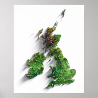
Poster Carte du relief des îles britanniques
Prix108,65 $CA

Poster Carte du relief des îles britanniques
Prix74,35 $CA
Produits
Voir tous les produitsPoster Carte du relief des îles britanniques
Prix74,35 $CA
Poster Carte du relief des îles britanniques
Prix108,65 $CA
CRÉATEUR